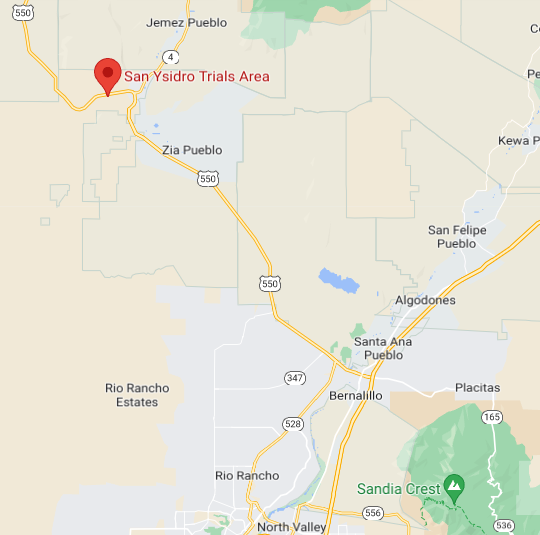
San Ysidro, NM
|
This area is public land (BLM) and is dedicated to trials riding. Full of rocks, sand and mesas, San Ysidro a is gorgeous desert with more traction than you'll know what to do with.
Directions: North from Albuquerque to Bernalillo (about 15 miles) then west on NM44 (550) about 22 miles to San Ysidro. Caution: Don't speed through San Ysidro. Proceed west on NM44 (550) towards Cuba one mile. On the north side of the road will be a gate. This gate is unlocked on trials days (but please close it behind you). On other days it is locked; contact a club member for entry. The riding areas are 1.2 miles up a sandy/dirt road which is usually passable by any vehicle. Spark arresters are required. This area is dedicated for trials. MX'ers, ATV's, and other such vehicles are not allowed. The area is sometimes grazed, and it is not unusual for hikers to be in the area; please play well with others! |
Event Dates for
2024 February 4th March 3rd April 7th November 3rd December 8th |
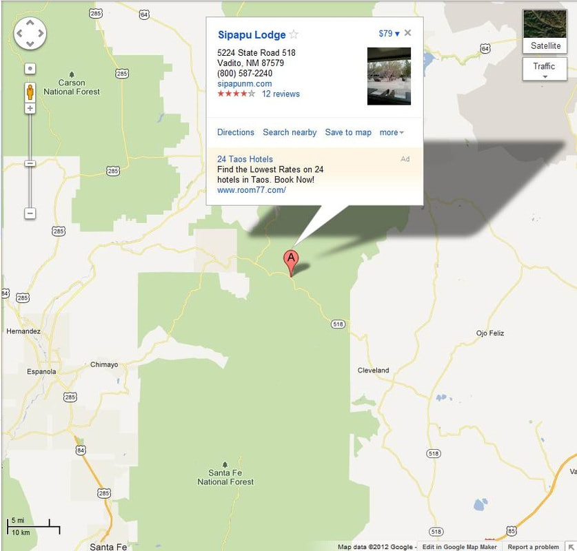
Sipapu, NM
Carson National Forest
|
Located in the Carson National Forest, in the beautiful Sipapu Ski Valley. This is a favorite for many of our members due to the camping and beautiful scenery. Visit their website at www.sipapunm.com
Directions: Sipapu is conveniently located on Highway 518, just 20 scenic miles southeast of Taos in northwestern New Mexico. |
Event Dates for
2024 July 13th & 14th |
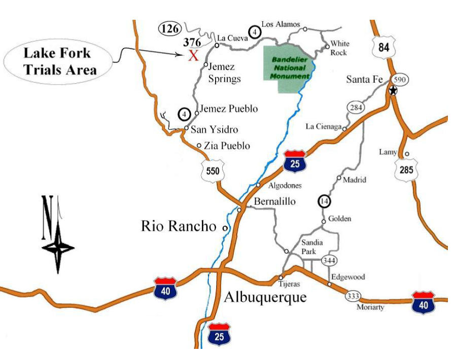
Lakefork (Jemez Mountain), NM
Santa Fe National Forest
|
Some of the best camping we have all year is at Lake Fork. Located in the Santa Fe National Forest, in the beautiful Jemez Mountains. Lake Fork event is fun for the whole family.
Directions: From Albuquerque take I-25, Exit 242 (US-550 Exit). Total distance from here is 57 miles, 1.5 hours. Take US-550 North toward San Ysidro for 23.5 miles. Turn Right onto NM-4 East for 26 miles. Be VERY careful of speed traps going through Jemez Springs. Turn Left on NM-126 for 3.8 miles. Turn Left onto Forest Service Rd. 376, it is a dirt road. Head down that for a couple miles, you'll be going down Lake Fork Canyon. The camping spot is along the road on your left. (Forest Service Rd. 376 continues down Lake Fork through the tunnels and comes back to NM-4 between Jemez Springs and Jemez Pueblo. A nice drive on a fairly good dirt road. The tunnels and gorge are really cool.) |
Event Dates for
2024 June 1st & 2nd August 10th & 11th |
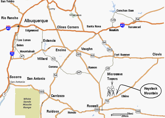
Roswell, NM
|
Roswell offers a great riding area with the amazing rock areas. This long drive for most of the club is well worth the time.
Directions: From Albuquerque take I-40 East, Exit 218 (US -285 Exit). Total distance from here is 155 miles, 2.6 hours. Take US-285 South for 134 miles. Turn Left onto US-70 East for 19.5 miles. Turn Left at the microwave towers on the Left side of the highway. The entrance to the parking area just past the towers and is a little hard to find, especially at night. Beware of high-speed traffic that’s not expecting you to be turning! |
Event Dates for
2024 October 12th & 13th |
Glorieta, NM
|
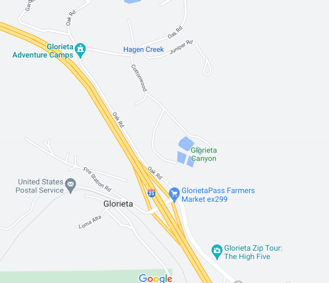
We had our first event for this location in 2022! Our club had such a great time and we are grateful for an opportunity to ride at a new venue. Access to the area is controlled, so if you are planning to ride, please make sure you pre-register. If you are planning to attend as a spectator, contact NMTA so that you can be provided with a gate code.
Directions: Take Exit 299 on I 25 turn left on to Oak road. Follow the road until you reach the gate. After entering the gate follow the road until you see NMTA arrow signs, they will direct you to the camping area.
|
Event Dates for
2024 September 7th & 8th |
Oachado, NM

|
A new location this year we'll have more information closer to the event date! Oachado (pronounced owah-shah-dew) in Mora County.
**PRIVATE PROPERTY OPEN ONLY ON SCHEDULED EVENT WEEKENDS OR BY PERSONAL INVITATION.** DIRECTIONS
Go north on NM 518 about 25 miles or 30 minutes to turn right onto NM 442 at La Cueva and the old water wheel mill (this turn is 5.3 miles or 7 minutes short of Mora), north toward Ocate. Go 4-1/2 miles to the Rainsville area, passing a logs and firewood business on the right. Continue 1/2 mile to turn left onto gravel Lucero Road (just past mm5 / marked as A021). On Lucero Road go 1.6 miles to Lucero, which is a cluster of old buildings where the road jogs right to become Coyote Road. Continue 1/2 mile to Oachado's red 16-foot steel gate on the left, just after Coyote Road dips. |
Event Dates for
2024 May 4th &5th |
Les Falaises, NM
|
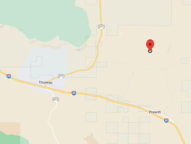
Les Falaises (lay-fah-lez) is French for 'The Bluffs.' Altitude is 6,900 to 7,300 feet. In the west part of New Mexico near Prewitt.
**PRIVATE PROPERTY OPEN ONLY ON SCHEDULED EVENT WEEKENDS OR BY PERSONAL INVITATION.** DIRECTIONS
From I-40 take Exit 63 Prewitt / Pillowcrest Road north to the frontage Old Route 66 (NM 122). Go right for 1/4 mile, then go left (north) onto McKinley County Road 19. Passing the entrance road to the Escalante power plant and the paper mill, continue on Road 19 another 1.9 miles to the overhead wood gate on the right having the sign 'Red Canyon Ranch'. Enter and follow the access road bearing right. Follow the intermittently spaced flagging ribbon to a steel gate on the left. Close the gate behind you and proceed to the destination. |
Event Dates for
2024 NO EVENTS SCHEDULED |
Gallup, NM
|
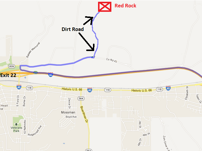
Red Rock Motorsports Park
http://redrockmotorsports.com/ Directions: 1. Take I-40 west from Albuquerque 2. Take exit 22 on the east side of Gallup 3. Turn right and then right again to go back the way you came on the frontage road (head east on Co Rd 43, Superman Canyon Road, Hassler Valley Road) 4. Turn left (north) on a dirt road with the Red Rock Motorsports sign 5. Follow the dirt road about a mile to the sign in station. 6. Sign the release. 7. Enjoy trials |
Event Dates for
2024 NO EVENTS SCHEDULED |
